Showing posts with label history. Show all posts

Blog Stew, Listed with Sotheby's

¶ Want to buy a southern Colorado ghost town? It has been mostly restored, and it is a National Historic District too. Listed with Sotheby's real estate division, so not cheap.

¶ Wolverines will not get federal protection in Colorado as a "threatened" species. The pro-protection argument was based on projected climate change.

¶ This sounds like something from the Daily Mail — but can the Lone Star Tick force you to become a vegetarian (or at least a piscavore)?

Changes in the Neighborhood, 1887 to Now

A. C. (or A. Q.) Monroe's Cash Store, 1887 (Denver Public Library)


I found this photo while researching the Squirrel Creek Lodge series. It was taken not far from where I live. My first thought was that that is more people than live on that road now.

My second thought was, "Maybe not, but the population skewed a lot younger in 1887. The school bus does not even come halfway up the road today."

Here is another photo dated 1887, with the store in the center. Click for a bigger image, and you will see a man sitting in a wagon.
Denver Public Library collection.
Not one of those buildings remains today. In the Teens and Twenties, some new cabins were built there— a little resort catering to the new automobile tourists, called "Greenwood Cabins," I have been told. Some friends have one of the cabins (no heating, no plumbing) on their property and use it as a summertime guest bedroom.

I wonder about the photo dating, though, because in the larger photo, the false front of Monroe's store is not missing a corner.(Update: See comments for probable explanation.)

I was in the area today (a cloudy day) and tried to replicate the photograph, lining up the two little rocky ridges on the hillside behind.

Actually, this is the biggest house on the road, so not typical of the area.
I think the store stood just to the left of the large house, which was built in 1989. There is a cement foundation there too, but I suspect that it is early twentieth-century. Those 1880 buildings were lucky to have a row of rocks in a shallow trench for a foundation.

And what were all those people doing? Ranching (the public land was open and un-managed) and small-scale sawmilling (ditto)? This was not a mining district. There were coal mines and even oil wells in the next county north, about 10–15 miles away, but back then miners usually lived within a mile of the mine and walked to work. There may have been some small dairy operations.

Denver Public Library collection.
One thing has not changed. A lot of backyard target shooting goes on. That is Mr. Monroe (of the store?) fourth from left. I don't recognize any of the surnames, although one of them, Holbert, is the name of a drainage about twenty miles north, as the Mexican spotted owl flies — M. and I found a nesting pair there twenty-two years ago when we were paid by the BLM to census owls.

I am tempted to check these names against the oldest graveyard hereabouts.

And the forest looks a little different too. Put that down to a century-plus of fire suppression and and cessation of local logging. It's mostly private land, with a little BLM at the far left of the ridge.

The burnt tree in the foreground of today's photograph is a relic of the 2,500-acre fire in 2012 that cleared away most of the houses on that side of the road.

Now there is a row of concrete foundations there for visitors of the future to wander among and wonder about.

Looking for Squirrel Creek Lodge - Part 4

Missouri-Pacific Railroad tourism brochure, 1927

Selling the San Isabel to Out-of-State Visitors

The first post in this series described Arthur Carhart's vision for scenic roads connecting campgrounds, picnic grounds, and private resorts in the Wet Mountains, the "cradle of car camping."

But what about out-of-state visitors? From the designation of Yellowstone National Park in 1872 into the 20th century, many North American tourists arrived at the nearest railway station to their destinations.

Then they might walk or take a coach to the nearest hotel. Some were grand, like the Banff Springs Hotel, built by the Canadian Pacific Railway in 1888–89. From the hotel, they could self-guided or escorted tours, such as by stagecoach from Livingston, Mont., into Yellowstone under U. S. Army escort (the Army patrolled the park until 1918, when the National Park Service took over). 

The Baver Li Lodge on Highway 165, late 1920s or 1930s.
The Missouri Pacific RR operated a route west from St. Louis to Pueblo, Cañon City, and on to Salt Lake City via Grand Junction. Eager to attract passengers, it provided this 16-page brochure about the San Isabel National Forest, "Colorado's newest playground." 

According to the grandson of the Baver Li Lodge's founders, the Missouri Pacific tried to buy the lodge (built in 1927) in 1929, but his grandparents would not sell. (It closed as a lodge in the 1960s but is still in the family.)

The brochure offered numerous one, two, and three-day automobile tours, for example, this one booked through the San Isabel Forest Tours Co. of Pueblo: 
"No. 1" — One day. Includes automobile transportation and mid-day dinner. From Pueblo via Rye and Willow Creek Camp to Squirrel Creek Community House [Lodge] for dinner; returning through Squirrel Creek Canyon [Colorado 76], Pine Drive to Pueblo. Fare, $8.00 per person.
Another day trip went from Pueblo to Wetmore and Westcliffe, included a meal at the Alpine Lodge, and returned through the Arkansas River canyon and Cañon City to Pueblo. When you consider that was almost all on gravel roads with a maximum possible top speed of perhaps 40–45 mph, it would have been a long day's car ride for your $10.50 fare.

In today's dollars, that trip cost $142 per person, according to a Bureau of Labor Statistics site. A cabin plus meals (fireplace heat, no plumbing) at the Baver Li Lodge cost $40–$50 in today's money (I would book one, definitely). I have not yet seen a menu for the Squirrel Creek Lodge, but I suspect that it featured fried chicken, since the archaeologists identified one foundation nearby as the chicken house.

The Missouri Pacific's brochure gushed about "Mountain Trout," "History and Romance," "The Wooliness of the West," "Altruistic Purposes" ("exorbitant charges for accommodation and services will not be countenanced"), "Scenic Grandeur," and "Special Vacation Summer Fares," among other headings.

One section, "The Hospitality of Colorado, reads as follows:
The spirit of wholesome friendliness is one of the refreshing pleasure to be anticipated in a visit to Colorado, and particularly to the San Isabel. The inhabitants of this country seem to be imbued with the bigness of their environs and manifest a sincere cordiality. In Colorado, all class distinction seems to be neutralized.
I wonder what areas we were being compared to.

To be continued at some point.

Looking for Squirrel Creek Lodge - Part 3

It's not just an incinerator, it is a "Kernerator,"
by the Kern Incinerator Co. of Milwaukee.

The US Forest Service's remaking of Davenport Campground into something like Arthur Carhart's original vision, as mentioned in my last post, was praise-worthy.

But does it make up for the Service's obliteration of much of Carhart's original vision for recreational faciltiies? Not really.

Under the supervision of Carhart and his former landscape-architecture professor-turned-business partner, Frank Culley, Boy Scouts and other workers built facilities on South Hardscrabble Creek — the Florence Picnic Ground — and on North Creek, just north of Beulah. Another picnic ground was built at Smith Creek, in Hardscrabble Canyon above Wetmore.

In the late 1970s, the Forest Service demolished them all. According to a friend of mine, a life-long area resident who attended a public meeting about this decision held in Beulah, the USFS representative claimed these facilities were "inacessible" and "rarely visited."

Another friend, a Westcliffe resident, said he had heard they were demolished due to vandalism problems. In any case, the Forest Service no longer wanted to maintain them.

Instead of picnic tables, trash receptacles, outhouses, etc., the new model was "dispersed camping." Tack up a sign saying "Pack in it, pack it out," and all is good. Of course, no one packs out human shit.

A lot of this dispersed camping takes place in very locations where Carhart laid out picnic and campgrounds!

We have come full circle back to 1919, except that the standard of environmental education among forest visitors is a little higher. Sometimes.

The incinerator built to burn trash from the 1920s Squirrel Creek campsites slowly crumbles away.

Arthur Carhart's contract with the Forest Service lasted only from 1920–1922, after which time funding was . . . lost. He went into private practice and did other interesting work, but eventually became a full-time writer of fiction and nonfiction with outdoor themes.

Just tonight, I heard a professional chef praising his The Outdoorsman's Cookbook. Of course, this praise was from a guy who has walked the Squirrel Creek Trail himself.

Until recently, recreation was not truly a Forest Service priority — at least that was my perception. As a specialty, it lacked prestige. From its early twentieth-century creation onward, the Forest Service was all about timber management — and also grazing management — and firefighting to protect those two priorities.

I remember Dad when he was a USFS district ranger in the Black Hills saying (without irony), "We're tree farmers."

As opposed, it did not need to be said, to the pressed-pants-wearing, somewhat sissified  (Dept. of the Interior) National Park Service rangers who led tourists around by the hand, (Dept. of Agriculture) Forest Service rangers did real stuff with horses, axes, increment borers, cruising rods, and log-scaling rules.

Recreation on his district was handled by one man, a "recreation guard," who lived in a cabin off away from the work center and had a crew of seasonal workers in the summer.

People who rose in the hierarchy came from a forestry background, not a recreation background, although that has changed some in the last generation.

But thanks to the San Isabel Public Recreation Association and Carhart's and Culley's work, private interests began pushing tourism in and around the San Isabel National Forest, something I will look at next.

Looking for Squirrel Creek Lodge, Part 2

Here are the 1947 flood waters one drainage north of Davenport Campground, near Baver Li Lodge.
What was then described as the Davenport Camp-Picnic Ground evidently survived the flood of 1947, which was most destructive in the narrow canyon of Squirrel Creek.

This photo is probably Davenport Picnic Ground in the 1920s, as the valley here is wider.
1920s-style cooking shelter recreated at today's Davenport Campground.
In 2004, Forest Service archaeologists Steve Seguin and Jennifer Cordova, together with historian Jack McCrory, prepared documentation to place the "Squirrel Creek Recreational Unit, " otherwise known as the "cradle of car camping," on the National Register of Historic Places.
Bases of guard rail posts at scenic overlook
on what was Colorado 76.

They listed all manner of remaining relics, down to guard rails and sign posts, but did not (so far as I noticed) say anything about a telephone line. But I found two mentions of a line that connected the Baver Li Lodge (of which more later), built in 1927, to the town of Beulah, running mostly along Squirrel Creek and the now-vanished Colorado Highway 76.

According to a 1967 article in the Pueblo Chieftain, summarized on this site,
The telephone line had been installed through Squirrel Creek by the Forest Service in the 1920’s. As their private line, Tena and later, grandson, Chuck, had to maintain it. Every spring one of them would ‘walk the line’ to find where the breaks had occurred and repair them. One year the Boy Scouts from Rye came up to help.
A short historical article about Beulah's Pine Drive Telephone Co. mentions it too:
One notable line was the one maintained from Baver-Li Lodge in Ophir Creek down Squirrel Creek. It took great fortitude to maintain that line after the ‘47 flood!

In 2009, as part of the U.S. Forest Service's centennial, Davenport was remodeled into a "retro" tents-only campground—and it remains popular.

You have to drive down into the campground (trailers and motorhomes should park above the entrance, in the Second MaceTrailhead parking lot) to see the interpretive signs.

There is nothing about Arthur Carhart's vision for forest recreation in any historical marker on any highway at this time. More signage, including a panel about him, has been proposed for the junction of Colorado 67 and 96 in Wetmore, part of the Frontier Pathways Scenic and Historic Byway.

Looking for Squirrel Creek Lodge, Part 1

It is 1923, you are suffering the summer heat in Pueblo, Colorado, and you want to go car-camping up in the cooler Wet Mountains. So you load your blankets, quilts, and canvas tent in and on the Ford, pack some flour and bacon, maybe grab a fishing pole, and off you go. You take Colorado State Highway 76 (a gravel road) southwest to the foothills town of Beulah, then stay on 76 as it enters Squirrel Creek Canyon and the San Isabel National Forest.
1948 San Isabel National Forest map shows Colorado 76 coming southwest from Pueblo.
Bridge dated 1916 on Squirrel Creek Road, formerly Colorado 76, in Beulah.
You know this part of the road is new — in fact,  it was laid out by Forest Service landscape architect Arthur Carhart. His former professor from Iowa State, Frank Culley, was involved too on the project to design numerous campsites along the road, all with hand pumps, designated concrete garbage pits, and "sanitaries" (outdoor toilets) — all a response to the trash and piles of human waste that popular campsites had been attracting.

The first picnic and camping sites there had been designated in 1919. That was just five years after the southern Colorado Coalfield War that culminated in the 1914 Ludlow Massacre. It was two years after the Russian Revolution, which had segued into civil war, and one year after the end of World War One.

Private money — the San Isabel Public Recreation Association (SIPRA) — helped pay for the first improvements. Colorado Fuel & Iron, southern Colorado's industrial behemoth, with its coal mines, coke ovens, and steel mill, was the largest contributor. Wholesome outdoor recreation will lure its workers away from Red agitators.

Carhart writes,
There is a chance in this sort of [forest] camp to teach better Americanization of the people of foreign blood now living in our midst . . . these men will become better citizens and far less open to insidious suggestions of the radical agitator to strike at this land they have come to know and love.*
Enjoying one of the new campgrounds on Squirrel Creek. Woman takes photo of men by fireplace. Check gen-u-wine ten-gallon hat on man in foreground.
The campgrounds are wildly popular. On summer weekend days, as many as 700 cars pass up Colorado 76, which connects to Colorado 165, the north-south road through the Wet Mountains.

Many people stay or take meals at the privately operated Squirrel Creek Lodge, a two-story log structure in the center of the camping area. It stays popular until the World War II era, when it faces competition from the San Isabel lodge (which also began as a SIPRA project).

But Carhart's cool, winding creekside road is vulnerable. Rockslides menace it from the slopes above, and in 1947, a major flash flood rips down the narrow canyon, destroying all the little bridges, tearing out campsites, and wrecking many parts of the road.

Squirrel Creek Lodge: A central room with two wings, front porch on the left.
Dinner • Refreshment • Lodging • Souvenirs.

Click to enlarge for photos of original lodge.
The lodge falls into disuse and eventually burns in a 1979 forest fire.

The state builds a new highway from Beulah to Colorado 165. Formerly the Twelve-mile Road, it is now designated Colorado 78, and it  takes a higher route up a ridge.

Its last nine miles are still gravel today, and according to a friend on the Custer County Road & Bridge Dept., are the last gravel stretch of a state highway. (Many state highways around here were gravel roads into the 1960s, when there was a big push to pave them.)

Mentally remove the young trees along the trail, and there is the old Colorado 76.
Hiker at mortared wall that marked a scenic pull-off on Colorado 76.
Colorado 76 devolves into a Forest Service trail — one that oddly features mortared-stone retaining walls, log guard rails, and steel culverts. It passes the ruined campsites, where campers improvise new fire pits, and the ruins of the Squirrel Creek Lodge and its associated cabins.

You, meanwhile . . . Dad is in the steelworkers' union and has a new car with a powerful V-8 engine. Mom doesn't wear those 1920s cloche hats anymore.

You can go anywhere — Yellowstone, Banff . . . no more chugging up Squirrel Creek Hill with the Model T threatening to boil over.

Remember those days when you were younger, when the Squirrel Creek campground was the oldest auto campground in the national forest?

Next: Part 2: Davenport, the "Retro" Campground

*Tom Wolf, Arthur Carhart: Wilderness Prophet  (Boulder: University Press of Colorado, 2008), 55.

100 Years Ago Today: The Ludlow Massacre and its Aftermath.

Funeral procession of miners' leader, Louis Tikas, in Trinidad, April 27, 1914 (Denver Public Library)

Today is the hundredth anniversary of the actual Ludlow Massacre, but the ambushes, gunfights, dynamitings, etc. started beforehand and continued for about ten days afterwards.

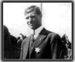
From the accounts  that I have read, the spokesman for the striking miners at Ludlow, Louis Tikas, was himself killed by Colorado National Guardsmen, no doubt "while trying to escape." He was born Ilias Anastasios Spantidakis in Crete.
Louis Tikas

I always heard—and this may just be urban legend—that the legacy of Ludlow is why there are no infantry units in the Colorado National Guard. I don't necessarily accept that as fact, but it is interesting as folklore.

Colorado Life magazine has a good article in their March/April 2014 issue, which can be ordered here.

Here is one summary from the official Ludlow Centennial website:
At the height of this conflict, on the morning of April 20, 1914, a skirmish broke out between striking miners and the Colorado State militia. This event, labeled the Ludlow Massacre, ended with the deaths of over 20 people, which included a guardsman, miners, and their wives and children. The death of children at the Ludlow Tent Colony thrust the Coalfield War into the media spotlight, with national scrutiny focused on the Rockefellers, who were majority shareholders in [the Pueblo steel mill and its mines] CF & I [Colorado Fuel & Iron]. In the aftermath of this tragedy, the Rockefellers and CF & I developed an employee representation plan that transformed industrial worker-company relations.
Stop by some time — Exit 27 from Interstate 25 north of Trinidad — and walk the ground.

But the fact is, even in Pueblo, not to mention the Denver-plex, 4/20 means something else these days.

The "Children of Ludlow"

One of my colleagues from the university recently referred to the students as "children of Ludlow, " claiming by analogy that they were being "massacred" by CSU system budget cuts.

It might not be the best analogy, though, if the reader has to look up the source that is unfamiliar. And I bet that 95 percent of Coloradans overall could not tell you what happened on April 20th, one hundred years ago.

The term "children of Ludlow" has a difference resonance for me.

For several years, a colleague in the History Dept. tapped me to be a judge on National History Day. Competing in different age classes, students from local schools might create posters-based exhibits, build dioramas, etc., and then they had to talk about them briefly to us judges as we came around. To quote the website, "NHD inspires children through exciting competitions and transforms teaching through project-based curriculum and instruction."

Imagine my surprise when I came across a sort of poster-triptych about the Ludlow Massacre, created by three middle-school boys. Something local, not another Martin Luther King, Jr., or other high-profile subject!

In talking with them, I asked if they had visited the site. It was only an hour-plus drive away but they would have needed a parent or someone to take them, being too young to drive themselves.

No, they had not. Learning the difference between primary and secondary sources was part of the project, so I said, "Look, the place is a primary source. You walk around on it and you see where things were — the tents, the machine gun, the railroad tracks where the engineer tried to move the freight train between the gunners and the camp . . . "

They looked at me like little birds. Maybe going there never occurred to them; maybe they felt unable to ask someone older for a ride, I don't know. Sometimes teaching in Pueblo was like teaching at the bottom of a well and wondering who would climb up and out.

To Be Continued

Taking the Hitchhikers to Ludlow

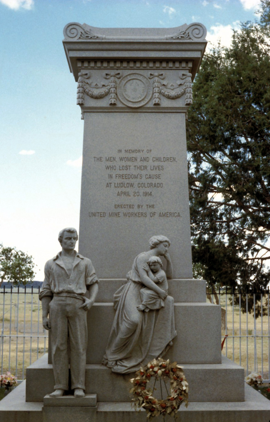
Ludlow Massacre monument (Wikipedia)
It was a summer day in the mid-1970s and I was driving my ten-year-old Ford pickup down Interstate 25, heading back from Denver to my summer construction job in Taos. (I had gotten a couple of days off; there was a lady involved.)

In my denim clothes and straw hat, I was feeling all southern-Colorado-native-ish, being about 20 years old and preoccupied with questions of authenticity and roots, even though — or because — for eight months a year I was also a student at a liberal arts college in Portland, Oregon. (The old pickup had Oregon plates, even while I carried a New Mexico driver's license.)

Then I saw them: two young guys hitchhiking on the south edge of Pueblo, and I figured to pick them up before some cop got after them for being on the interstate. They were from New Jersey, as I recall, going to Santa Fe — and I could get them closer.

We went down the road, talking about their journey West, etc., and to them I was just this guy from Taos with a faint northern-New Mexico accent (courtesy of the crew I was working with). And I decided that they should see Ludlow as part of their Western experience.

We took the lonely exit, bumped over the railroad tracks and past the United Mine Workers billboard over a little rise to the memorial: the statues, the picnic ground, the plaques.

I did not have to play history guide: the story is there.

And now my memory breaks down.

Did I make up some story to leave them out there on the prairie between Trinidad and Walsenburg?

The quickest way to Taos would have been US 160 west over La Veta Pass, then south. But to get there from Ludlow I would have had to drive back north to Walsenburg first.

And I have a memory of coming down the west side of La Veta Pass, getting panicky because the oil pressure light started flickering— worrying that the oil pump was failing (they rarely do). And driving south through San Luis and Questa, heart in mouth, not wanting to break down, only to learn later that it was merely the sending unit going bad that caused the warning light to flicker.

Or was the whole experience an example of road-hypnosis hallucination? I've had several of those over the years.

To be continued.
Older Post ►
 

Copyright 2011 Southern Rockies Nature is proudly powered by blogger.com